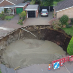
The results of a survey of the roadway and footpath at the site of the St Albans sinkhole have been published by Hertfordshire County Council.
A geophysical survey of the road and footpath in Fontmell Close and Bridle Close took place between 3 and 11 October after a 12 metre diameter and 7 metre deep sinkhole appeared in the early hours of Thursday 1 October.
The Geotechnology microgravity survey, commissioned by Hertfordshire County Council, has shown that the collapse occurred within the boundary of a backfilled clay pit that had been excavated in the 19th century for brickmaking and backfilled with waste from the area.
Chalk excavation in the bedrock beneath the clay pit is the most likely explanation for the cause of the collapse. Although there is no documented evidence of chalk mining, the presence of a limekiln is evidence of chalk use.
In summary, a number of anomalies have been identified, one of which appears to have characteristics similar to that which resulted in the sinkhole. Initial modelling suggests this could be larger than the existing collapse, possibly by up to three times. Further investigation will be necessary.
It has yet to be decided what further work will be carried out. We know that further investigation is needed, possibly intrusive investigations, and are working with householders and their insurers and loss adjusters on the best way forward.
Our priority remains to ensure the safety of residents in the area and minimise disruption.
Meanwhile, Hertfordshire County Council is looking into the feasibility of a longer term solution to the temporary access road created for residents in the area.
Reproduced for the Herts direct website. For further information see http://www.hertsdirect.org or subscribe for our latest editions here
Image and Micro Gravity Report Geotechnology Ltd
http://www.hertsdirect.org/docs/pdf/f/fontmellclsefinalreport2015.pdf
The equivalent of around 6,687 bathtubs full of foamed concrete was pumped into the sinkhole


